Concrete & Structure Scanning
We understand that concrete scanning and inspection can be a complicated chore. The Underground Detective offers a way to perform ground penetrating radar scans of concrete structures simply and safely. We then present data clearly for real-time and in-the-box 2D or 3D data acquisition, display, and analysis.

How do we do our Concrete Scanning Services?
The Underground Detective presents GPR scans of concrete structures clearly for real-time and in-the-box 2D or 3D data acquisition, display, and analysis using the most flexible and comprehensive concrete scanning systems on the market.
With the unstoppable team of The Underground Detective, you will finally be able to avoid damaging conduits, wasted time and money by scanning directly into the concrete before you saw or core drill.
Scanning Equipment
We use the most flexible and comprehensive concrete scanning systems on the market. With The Underground Detective’s technology, you will finally be able to avoid wasted time and money by scanning directly into the concrete before you saw or core drill. No longer will service shutoffs and accidentally cut conduits keep you from getting the important work done. The Underground Detective helps you efficiently meet your deadlines and move on to the next job.
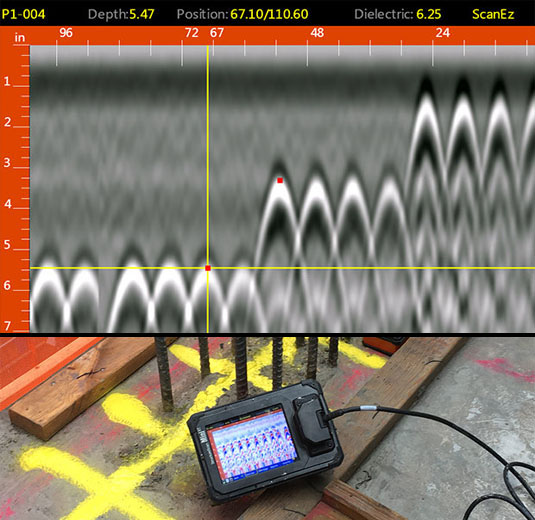
Our equipment provides accurate inspection of concrete structures such as floors, walls, slabs, and bridge decks. We are able to detect metallic and non-metallic objects and features such as rebar, post tension cables, metallic/non-metallic conduits and pipes, and voids, as well as measure slab thickness.
Concrete Scanning Case Study – Another Odd Job
Typical concrete scanning services involve on-the-ground scanning of concrete structures such as floors, walls, concrete slabs, and bridge deck, or the roadway/pedestrian walkway surface of a bridge.
Often we get calls which are a bit out of the ordinary. One time, a call was regarding a newly built water tower on Cincinnati Dayton Road in Monroe, Ohio. With water towers, like many concrete structures, samples of the concrete are required to be inspected while constructing it to make sure the concrete is up to code. On this particular project, they typically take samples from the concrete trucks as they are dumping it into the concrete pumper. For whatever reason, one load of concrete did not get tested. This, of course, was the concrete that was placed at the very top of the tower.
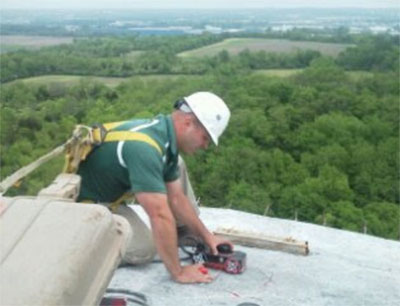
To meet the inspection requirements, they were required to core drill the concrete on top to make sure it met their specifications. We were called to make sure that no rebar, also known as reinforcing steel, was hit during the core drill sampling. Using the proper fall safety equipment, our technician, Jason, was sent to the top of the tower to perform the concrete scanning. He was able to locate all of the rebar they needed which helped the project stay on the proper timeline.

Concrete scanning with a view at the top of the water tower in Cincinnati Dayton Road in Monroe, Ohio.
It’s time to stop losing time and money with accidents that can be avoided. The Underground Detective wants to detect your utilities before your shovels do.
Request a quote today to see what our concrete scanning services can do for you!
FAQ About Concrete Screening
In dry sandy soils, it can reach depths of 50’ or more. In moist clay or wet soil, the GPR signal is absorbed and decreases the penetration of the signal to 0-3’. Although the signal may not penetrate to a utility in moist clay or wet soil, there is the possibility of seeing trench lines where the clay has been disturbed.
By law, 811 has to be called before we are allowed to double check their work, especially on excavation projects. If utility information is needed for survey purposes, after you have waited the required time for your state, we can assist in locating their utilities.
Approximately 15’ in moist clay or wet soil and 25’ in dry sandy soil.
Possibly. Plastic is non-conductive, so electromagnetic locating equipment will not work. We will have to attempt with ground penetrating radar. Soil type and conditions will determine if we can locate it or not. Dry, sandy soil is best case scenario, while moist clay and wet soil is worst case.
Most of time we can using ground penetrating radar for this.
If a tracer wire is not present, we would have to attempt with ground penetrating radar. Soil type and conditions will determine if we can locate it or not. Dry, sandy soil is best case scenario, while moist clay and wet soil is worst case.
Pictures, a report, and a non-survey grade map are provided immediately after the job is complete.
With our push camera in pipes 3”-8”, we can approximately go 300’. With our CCTV tractor camera in pipes10”-24”, the distance is approximately 600’.
Yes, we will use ground penetrating radar.
Depths are accurate approximately 85% of the time. For this reason, we cannot guarantee depth. If depth to the inch is crucial, using vacuum excavation to physically expose the utility is your best solution.


