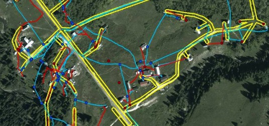
Underground Utility Mapping
After carefully collecting utility information using electromagnetic locating equipment, ground penetrating radar (GPR), and locating sondes, The Underground Detective will provide a non-survey grade map that can include shapefiles, kml, or other digital formats that outline and define what utilities are located.
If they exist at all, underground utility maps are often incorrect. Sometimes utility pipes or cables are relocated during repairs and renovations, but maps are very seldom updated. Maps signify projected plans that don’t show as-built locations. Sometimes, old maps are simply lost and forgotten until a project comes up in which they are needed. The result of digging or drilling in the presence of unidentified, unmarked, unmapped, or incorrectly located utilities can be wasted excavation time and money, can cause expensive damage, create utility outages, and worst of all, could potentially inflict personal injury or death.
After the utilities have been located, they are marked using color-coded pavement paint as well as color-coded flagging. Have you ever pulled into a parking lot or a gas station and noticed the lot is spray painted with assorted colors? Have you ever driven through a neighborhood and noticed a yard with many small, colored flags throughout it? Those markings are utilities that have been mapped out and located!
Mapping Projects with the Underground Detective
- Capturing Utilities: water and gas pipes, electrical and communication lines
- Capturing Irrigation Information: pipes, sprinklers, valves, controllers, and irrigated areas
- Site Plans: buildings, evacuation points, emergency info, fire hydrants , and chemical storage areas
What’s your project? Request a quote from Underground Detective today to get started!


